
MOUNT KUN
12.10.2023
MOUNT KUN , Daily Current Affairs , RACE IAS : Best IAS Coaching in Lucknow
|
For Prelims: Mt. kun,Zanskar Range,The Yellow River For Mains GS paper 1 :About mt kun,Historical Significance and Cultural importance,Geographic Features of Mount Kun,Environmental Significance |
Why in the news?
Recently, One soldier died and three are missing after a group of Indian Army mountaineers was caught in an avalanche on Mount Kun in Ladakh.
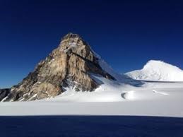
Key Points
- It also known as Kunlun, is a prominent mountain range in Central Asia that extends through China, Tibet, and parts of Pakistan and India.
About Mount Kun
Geographic Location
- It is a part of the larger Kunlun mountain range, is situated in Central Asia.
- It extends across several countries, primarily China and Tibet, and stretches from the Pamir Mountains to the Qilian Mountains.
- The range is known for its impressive peaks, including Mount Muztagh Ata and Mount Kongur.
- It is the second-highest peak of the Nun Kun massif, standing at an elevation of 7077 meters.
- It is located near Sankoo in the Suru valley, Kargil district, Ladakh.
- These peaks are among the highest in the Zanskar Range on the Indian side of the Line of Control.
Mountaineering
- The first person to climb the Kun peak was Italian mountaineer Mario Piacenza in the year 1913.
- However, it took 58 years for an Indian Army Expedition to successfully climb the mountain again.
- The climb to the summit is technically challenging and demands extensive knowledge of mountaineering techniques like using ice axes, roping up procedures, crampons, and jumar climbing.
Historical Significance
It has a rich history, with archaeological evidence suggesting that it was a crucial route on the ancient Silk Road.
Cultural and Mythological Importance
- It has deep cultural and mythological significance in Chinese and Tibetan traditions.
- It is often associated with stories of mythical creatures and is considered a sacred place by many indigenous communities.
Geographic Features of Mount Kun
Formation and Geology
- It has a diverse geological history, with rocks ranging from sedimentary to metamorphic.
- It has been shaped by tectonic forces and glacial activity over millions of years.
Glaciers and Rivers
This mountain are the source of several major rivers, including the Yangtze and Yellow Rivers in China.
Environmental Significance
Biodiversity and Ecosystems: Despite the harsh climate and high altitudes, Mount Kun hosts a variety of wildlife and plant species, some of which are unique to the region. It is home to rare species like the snow leopard and Tibetan antelope.
Climate and Water Sources: The mountains significantly influence the climate of the surrounding areas, particularly the monsoon patterns in the Indian subcontinent. They also serve as vital water sources for millions of people living downstream.
Mount Kun in Culture and Religion
Influence on Art and Literature: The majestic beauty of Mount Kun has inspired artists, poets, and writers for centuries, resulting in a rich cultural legacy.
Role in Buddhism and Taoism: This mountains have deep spiritual significance in Buddhism and Taoism, with monasteries and temples dotting the landscape. They are associated with meditation and religious retreats.
Zanskar Range:
- It is situated in the Ladakh region of northern India.
- It lies to the north of the Great Himalayan Range and runs parallel to it.
- The range stretches for approximately 400 kilometers (250 miles) from the western end of the Indian state of Himachal Pradesh to the eastern border of Ladakh with Tibet.
- It separates Ladakh from the valleys of Kashmir and the Chenab River on one end, and Kinnaur from Spiti in the Himachal Pradesh region.
- In other words, it acts as a border line between Kashmir's Ladakh area and the state's other two regions, Jammu region and Vale of Kashmir.
- The average height of the Zanskar Range is about 6000 m.
- The highest peak in the Zanskar Range is Kamet, which is 7,756 meters (25,446 feet) high.
Passes: Most important passes are Zojila, Shipki, Lipu Lekh (Lipulieke), and Mana.
Rivers:
- Many rivers originating in different branches of this range flow northward, and join the great Indus River.
- These rivers include Shingo River, Zanskar River, Hanle River, Suru River (Indus), and Khurna River.
The Yellow River (Huang He)
- It is the second longest river in China (after the Yangtze).
- It’s the fifth-longest river in the world.
- Tributaries: Black River, White River, Tao River, Huangshui, Fen River, Luo River, Wei River.
- The name “Yellow River” comes from the huge amounts of “yellow” loess sediment it carries, which are eroded when it flows through the Loess Plateau.
- It is not just an iconic river of China, but also the symbol of the Chinese spirit: bearing burdens (its sedimentation), adaptation (its course changes), and perseverance (its continual flow).
- Hukou Waterfall on it is the second-largest waterfall in China.
- Qinghai Lake on it is China’s biggest lake.
Source:India Today