India’s Coastline is Now 11,988 km Long: The Science, Significance, and Shifts Behind the Measurement
India’s Coastline is Now 11,988 km Long: The Science, Significance, and Shifts Behind the Measurement
India, known for its vast and diverse coastline, has recently updated its official shoreline measurement for the first time in over four decades. The length of India’s coastline, long considered to be around 7,500 kilometers, has now been revised to 11,988 kilometers, marking a 47% increase. This dramatic shift doesn’t reflect a geographical expansion but is the result of more accurate and refined measurement techniques. The revision carries implications for coastal planning, national security, environmental conservation, and governance. It also draws attention to the scientific complexities of defining a coastline in the first place. This article explores the underlying reasons for the revision, the science behind coastal measurements, and what this means for India’s future.
Why the Coastline Length Increased
The previous estimate of India’s coastline—approximately 7,516.6 km—was derived using methods and technologies dating back to the 1970s. These earlier calculations adopted a straight-line method, connecting prominent coastal points on large-scale maps. As a result, finer details such as small inlets, lagoons, and curving shorelines were omitted. This simplification significantly reduced the perceived length of the coastline.
In the latest revision, officials adopted a scale of 1:250,000 instead of the earlier 1:4,500,000. A smaller-scale map captures only broad outlines, while a larger-scale map is able to register more intricate coastal features. In simple terms, the finer the scale, the more shoreline gets included in the measurement. The new approach follows the high water line, the point on the shore that water reaches during high tide. This method provides a far more accurate depiction of the coast and includes areas that were previously excluded.
Thus, the updated coastline length—11,988 km—is a more precise reflection of India’s true coastal geography. Importantly, this does not represent any increase in India’s land area or territory, but rather a refinement in how that area is understood and recorded.
The Coastline Paradox: Measuring the Irregular
The sharp increase in coastal length highlights a mathematical and geographical concept known as the Coastline Paradox. First identified by Lewis Fry Richardson, a British mathematician, the paradox illustrates how the length of a coastline varies depending on the scale of measurement. Coastlines are inherently irregular and resemble fractal structures, meaning they reveal more complexity the closer you look.
In simpler terms, the more detailed your measuring instrument, the longer the coastline becomes. This is because every curve, indentation, and rock formation adds to the overall length. A rough approximation using straight lines misses these features, while a detailed survey accounts for them, thus stretching the measured distance.
India’s coastline is particularly susceptible to this paradox because of its geological and ecological variety—from sandy beaches and rocky cliffs to mangroves and river deltas. Recognizing the coastline as a dynamic, irregular boundary helps shift the focus from a simplistic length to a more nuanced understanding of coastal complexity and vulnerability.
Tools That Enabled Precision
Modern technology played a key role in enabling this revision. The update was carried out by the Survey of India using a combination of Geographic Information Systems (GIS), LiDAR (Light Detection and Ranging), GPS, satellite imagery, and drone mapping. These technologies allowed surveyors to measure every minor geographic feature that had been previously overlooked.
Furthermore, the calculation incorporated data from the Electronic Navigation Charts of the National Hydrographic Office (2011). These charts were particularly useful for mapping coastal water lines and shallow maritime zones. The revision also considered inshore islands connected to the mainland during low tides or by man-made linkages like roads or railway bridges—features that had not been consistently accounted for in earlier surveys.
The Indian government now plans to revise the coastline length every 10 years, making it a recurring national assessment to reflect both environmental changes and technological advancements.
Which States Saw the Greatest Change?
The most striking increase in coastline length was seen in Gujarat, where the revised measurement surged from around 1,214 km to 2,340 km. Gujarat's geography—marked by estuaries, gulfs, and creeks—naturally lends itself to greater variation, and the detailed measurement captured this complexity. Gujarat alone added over 1,100 kilometers to its official coastal length, accounting for nearly one-third of the national increase.
West Bengal reported the second-largest jump, followed by Tamil Nadu, which has now overtaken Andhra Pradesh in terms of coastline length. Kerala, despite its well-defined and long-known coast, recorded the smallest increase—just about 30 km, roughly a 5% change.
Interestingly, the Union Territory of Puducherry experienced a decline of 10.4% in coastline length. Experts suggest this could be due to changes in sediment deposition, erosion patterns, or human interventions like port construction and land reclamation. Such localized alterations further underscore the importance of periodic re-evaluation of coastal data.
National Coastal Spread: States and Territories
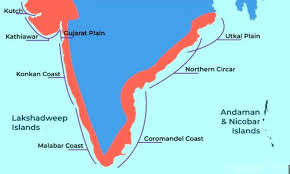
India’s revised coastline stretches along three major water bodies: the Arabian Sea, the Bay of Bengal, and the Indian Ocean. A total of nine Indian states share a maritime boundary: Gujarat, Maharashtra, Goa, Karnataka, Kerala, Tamil Nadu, Andhra Pradesh, Odisha, and West Bengal. Additionally, four Union Territories—Daman and Diu, Lakshadweep, Puducherry, and the Andaman and Nicobar Islands—have coastlines.
The updated coastline length of 11,988 km now brings India’s maritime border almost in line with its land boundary of 15,106 km, reaffirming the country’s status as a major maritime power. This change is not just academic—it has strategic significance for sectors such as defense, shipping, fisheries, and disaster management.
India’s coast is diverse, comprising rocky shores, sandy beaches, mudflats, estuaries, mangrove forests, lagoons, and marshlands. This diversity adds ecological, economic, and strategic importance to every kilometer of shoreline.
Looking Ahead: What the Update Means
The implications of this updated coastline are far-reaching. It will affect urban planning, environmental protection, climate resilience, and national security strategies. For example, India's Coastal Regulation Zone (CRZ) laws, first issued in 1991 and updated in 2019, rely heavily on accurate coastal data to restrict construction in vulnerable zones. These regulations will now need to be revised to align with the new shoreline figures.
Additionally, state governments will be required to redraw Coastal Zone Management Plans, reclassify high-risk zones, and update disaster preparedness strategies for cyclones, tsunamis, and flooding events. Coastal development projects—whether ports, industrial zones, or tourism hubs—will also require fresh environmental assessments.
There are also national security implications. Historically, India has focused more on land-based defense threats, but the extended coastline necessitates stronger maritime surveillance, naval infrastructure, and coastal policing. Analysts suggest that this revision may support arguments for increased funding for coast guard operations, naval expansion, and port security frameworks.
The decision to conduct this recalculation was initiated by the Coastal Protection and Development Advisory Committee (CPDAC) in 2010, and was finalized in 2023 at the request of the National Security Council Secretariat. It took more than a decade of planning and coordination to arrive at the updated measurement.
Conclusion
India’s revised coastline measurement is a powerful reminder of how technology, geography, and policy intersect in shaping our understanding of natural borders. Moving from 7,500 km to nearly 12,000 km is not merely a statistical correction, it represents a paradigm shift in how we view coastal India. It reinforces the need for scientific precision, adaptive governance, and long-term sustainability in managing our fragile yet vital coastal ecosystems. With rising sea levels, increasing population pressures, and geopolitical shifts in the Indo-Pacific, the importance of an accurate and detailed understanding of India’s coastline cannot be overstated.